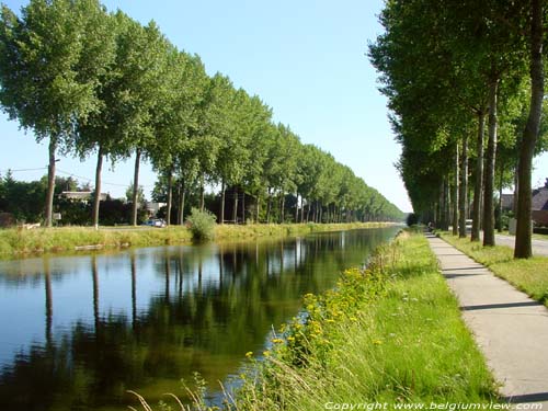
This waterway called ' Damse Vaart ' is also known as 'Canal of Napoleon'. Spanish warprisonners carved it out from 1810 on on the order of Napoleon. He wanted to be able to escape through a canal that connected Bruges with Breskens in case of a continental blockade.AT the beginning it follows the old Reie and then the old Zwinarm.
At the moment of the fall of the emperor it reached a little further than Hoeke and the works were stopped.
We thought: 'In 1858 they started again and were definitvely stopped because of lack of financial funds reaching Sluis.'
This was corrected by Guido Vermeersch: 'When Napoleon was defeated, the canal passed till fort Saint Donas in Lascheure. In 1858, the town Sluis continued the canal till its centre, in the hope to improve its commercial position in trading the famous Zeeuws agricultural products (selling them to Bruges, Ghent and Ostende).
From the start of the works on polpars of Mariland were planted along the dykes. There are about 800 trees, the oldest ones are now from 1922 and 1923. The trees are cut down when they are about 90 years and replaced by new ones.
Nederlands
Français
  
|